
The following saying has never been more true than for WH Edmunds. His maps are the jewels in the crown of the Map Collection of the State Library of SA.
"Maps are a marriage of art and science."
Who was WH Edmunds?
William Herbert Edmunds, known as Will, was born on 30 August 1872 at Alberton, the seventh of ten children. The family moved to the mid north, where his father was a stipendiary magistrate based at Gladstone. He showed an early interest in drawing, passing a Model Drawing examination as a 16 year old. Will attended St Peter’s College in Adelaide from 1887 to 1890 where his talents were more sporting than academic. He made the pages of the college magazine as a middle distance runner, hurdler, gymnast, underwater swimmer, cricketer and footballer.
Until the Federation, the Australian colonies relied on volunteer forces. Will joined the Gladstone Volunteers in 1888 when he was 16 and was soon taking part in South Australian National Rifle Association matches at the Port Adelaide firing range, as well as local events. The Express and Telegraph of 14 September 1891 wrote;
"Private WH Edmunds, a new shot, who hails from the north, is a young rifleman, and judging by his shooting during the past week he will be heard of in the future."
Indeed he was, being selected in the South Australian rifle team in 1893. After leaving Gladstone, he joined the Adelaide Rifles, which became the 16th Australian Light Horse Regiment. Edmunds remained in the volunteer forces—the equivalent of today’s Army Reserve- virtually for the rest of his life, reaching the rank of Major. He was awarded the Volunteer Officers' Decoration (V.D.) for long and meritorious service.
In 1899 the Anglo-Boer War began, now known as the South African War. By 1900 the military authorities realised they needed to recruit bushmen with experience with horses, to survive in the veldts (grasslands) and kopjes (hills) of Transvaal and the Orange Free State. So Lieutenant Edmunds volunteered for service, embarking on the transport Ormazon on 9 February 1901 as eighth in command of the Fifth Contingent South Australian Imperial Bushmen. He enjoyed the experience and acquitted himself well. His drawing and riding skills became useful in reconnoitering and making sketches of the country for the use of the Contingent. He returned on the transport Manchester Merchant on 27 April 1902. Colonel de Lisle commanding the fifth and sixth Contingents commented that;
"Lieutenant Edmunds and the other young officers with the South Australians are splendid fellows. I have never seen finer young men."

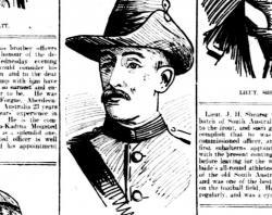
A caricature of Lieutenant Edmunds, South Australian Register 9 February 1901. NLA: Trove.

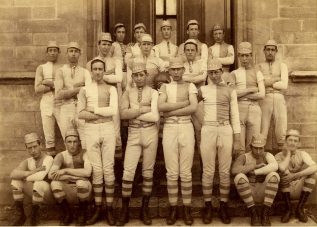
Lieutenant Edmunds is in the centre of the middle row of the officers of the 5th South Australian Imperial Bushmen. SLSA: B 49571.

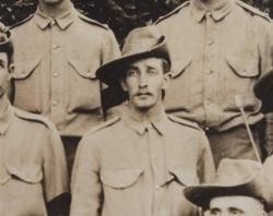
Close up of Lieutenant Edmunds, 1901-02. SLSA: B 49571.
In 1898 Edmunds joined the Surveyor General’s office where he worked until his retirement in 1934, with a stint as Engineer with the Naracoorte Council 1903-07. At the Surveyor General’s office, he started in the field staff unit, his duties included surveying pastoral country, sketching features of the country, taking levels around bores, doing surveys for townlands, re-surveys, and blocks for village settlers. Later as a draftsman, his duties included working on special plans related to the Census, Federation, pastoral land, vermin boards, and district councils, much of its administrative work rather than map-making.
In 1910 he made a bold move. He suggested to his state government employer that he be seconded to the commonwealth Defence Department for two years to undertake topographical mapping, in the absence of interest in this area in the Survey Office at that time.
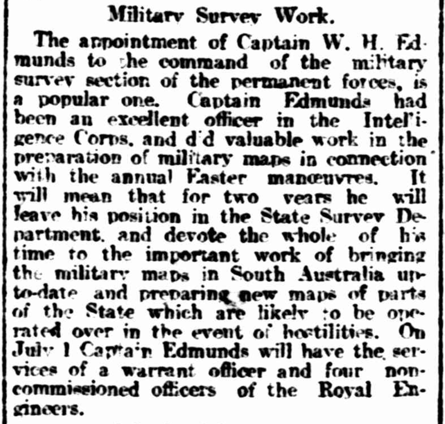
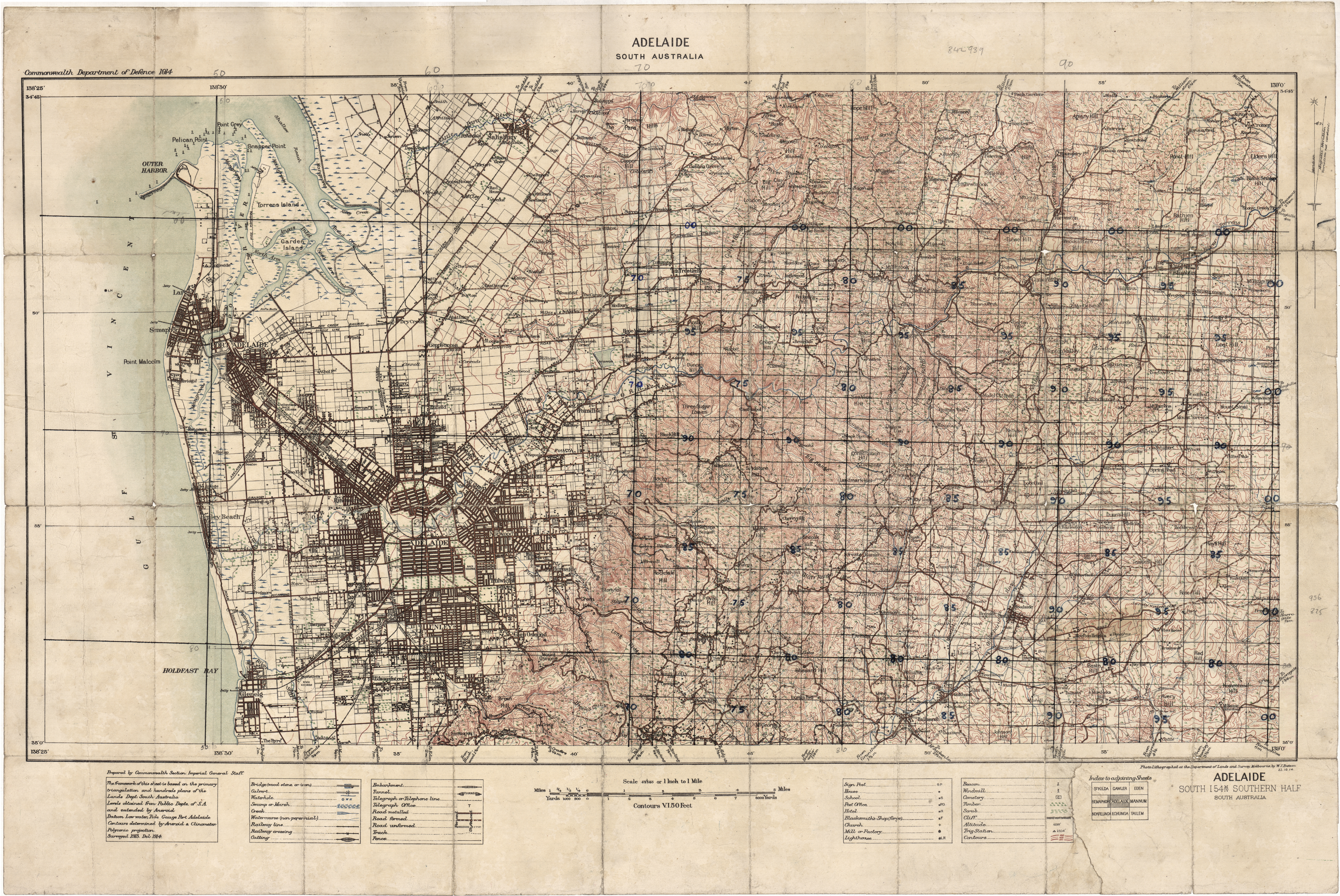
Edmunds produced South Australia’s first topographic map Adelaide, South Australia in 1914. A topographic map is a graphic representation of the lie of the land—the contours and spot heights that aid walking through the country—and also shows cultural features. The significance of the work he did in these two years is highlighted by John Lines in his 1992 book Australia on paper: the story of Australian mapping:
"Edmunds was largely responsible for the production of the Adelaide topographical map in 1914. This was to be the only 1:63,360 topographic map available in South Australia for the next twenty years. Edmunds was the first to undertake series mapping in South Australia and was virtually a one-man band in topographic mapping, as the Lands Department along with other departments in the state, had no interest in accurately depicting the topography."
After the two-year secondment, Edmunds returned to his job as a draftsman in the Survey Office, which continued to have other priorities than topographical mapping. So in his own time, he worked on producing his own topographical maps and publishing them privately.
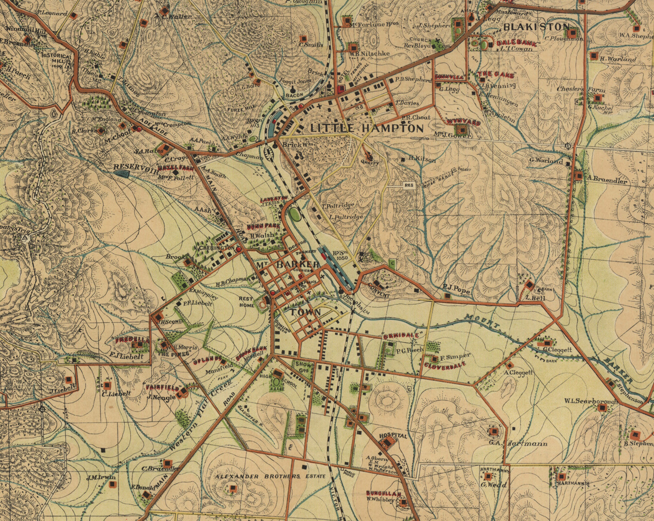
The case of Mount Barker tells the story. An article in the Mount Barker Courier of 23 January 1914 notes that military surveyors were in the vicinity of Mt Barker in charge of Mr Edmunds who has special knowledge of this kind of work, and they are drawing up a complete chart of the local country.
“They will take many years to complete” remarked Mr Edmunds “but I am doubtful as to whether the charts will be available to the public when they are finished”.
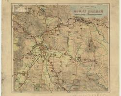
There is no record of this chart in the Map Collection but some 19 years later Edmunds tells the Mount Barker Courier of 22 December 1933 that ‘for the past 25 years he has been engaged in the preparation of topographical maps as a hobby. A desire to have a map of Mt Barker was recently expressed. He would like residents to give assistance in his work by giving what information they can, that they name their houses and farms’. Three years later he publishes the beautiful Topographic sketch of Mount Barker.
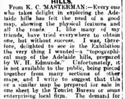
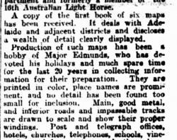
With the arrival of the motor car in the 1920s came the tradition of the Sunday drive in the Adelaide Hills, as well as touring around the state. In 1926 Edmunds published a group of six maps in a booklet as Topographic maps of South Australia covering the areas surrounding Aldgate, Brighton, Henley, Millbrook, Semaphore and Uraidla. His plan was to cover the rest of the state so that a complete wall map could be built up, but this did not eventuate. Two articles in the newspapers highlighted the need for these maps.

Topographical Map of the Hills. Observer 18 April 1925, NLA: Trove.

Topographical Maps, Ideal for motorists. News 2 March 1927. NLA: Trove.

Topographical sketch of Mount Baker, SLSA: Map Collection C285.
How were the maps produced?
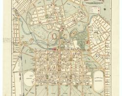
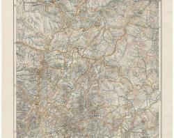
Edmunds used the standard tools of the time—an aneroid barometer and a plane table allowing plotting of the plan and field observations to be done simultaneously—and his transport was on foot or horseback. The largest and most striking of his maps is the Road plan of Adelaide Hills of 1938, which occupies pride of place near the Information Desk of the Spence Wing in the State Library. In contrast with his topographical maps which show the lie of the land, in 1936 for the centenary of South Australia's European colonisation, Edmunds recreated in his own inimitable way, William Light’s 1837 plan of Adelaide and North Adelaide.

Adelaide, 1936. SLSA: Map Collection C 228/1.
This image has been cropped and used as the hero image for this story.

Road plan of Adelaide Hills, 1938. SLSA: Map Collection C283.

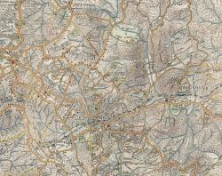
A section of the Road plan of Adelaide Hills featuring the Crafters to Bridgwater section. SLSA: Map Collection C283.
In his personal life, Edmunds married Jean Thomson from Burnside Station near Gladstone on 19 April 1906. They had three children—Margaret Jean and twins William David and Robert Joseph—known as Bill and Bob. The family lived at ‘Burnlea’ 101 Osmond Terrace in Norwood which had a tennis court and a barn where Will painted and prepared his maps. The house is on the local council’s heritage register. Edmunds died on 23 October 1943 at the age of 72, and he is buried in North Road Cemetery in Plot 8740 Path 48 South.
What is his legacy?
The WH Edmunds maps are much loved by staff, researchers and visitors to the State Library. His maps are often reproduced where historic and cultural assessments need to show before-and-after landscapes, so are still valued as colourful and accurate representations of the landscape and the people who lived there.
Explore Edmunds' maps
Adelaide South Australia, 1914
Adelaide South Australia sketch map, 1915
Adelaide, 1936
Adelaide Hills topographic map, 1920
Adelaide Hills road plan, 1938
Aldgate topographic map, 1926
Bagot’s Well camp area, 1940
Brighton topographic map, 1926
Clare and environs topographical sketch, 1931
Gawler manoeuvre area reconnaissance sketch, 1914
Gawler-Smithfield camp area sketch plan, 1914
Glenelg-Clarendon area, 1940
Henley topographic map, 1926
Millbrook topographic map, 1926
Mount Barker topographic sketch, 1936
Mount Gambier, 1939
Mt Lofty topographical sketch, 1928
Norton’s Summit topographic sketch, 1928
Overland Corner: Hundred of Parcoola, 1916
Port Victor and environs, 1914
Semaphore topographic map, 1926
Uraidla topographic map, 1926
Woodside topographic sketch, 1936
Written by Carolyn Spooner, Engagement Librarian